If you thought the year's extreme, climate change-induced weather would be limited to widespread and punishing heatwaves, sorry — there will be hurricanes too. Experts at the Colorado State University are forecasting a "borderline hyperactive" hurricane season, with as many as nine hurricanes predicted to form in the Atlantic basin.
As we've covered previously (here and here), some parts of the US are more prone to weather and climate disasters than others — but which face the highest risk of hurricanes?
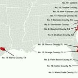
Gutter Gnome compared 318 counties on metrics across risk, hurricane history and financial impact, and ranked them according to their subsequent hurricane risk score.
Key Findings:
-
The two worst spots for hurricane vulnerability overall are in Florida: Broward County and Palm Beach County.
-
All but one of the ten most hurricane-prone counties are in Florida, North Carolina or South Carolina. The only exception is Chatham County, Georgia.
-
Much of Texas and the New England area are at very low risk of hurricanes.
Click image to enlarge
Via Gutter Gnome.

