Top Tech Stories
1
Top Story
Nvidia Leads Letter Warning Against Overregulating Open AI Models
Letter signed by Microsoft, Palantir and others argues open models boost U.S. competitiveness, safety and innovation.

2
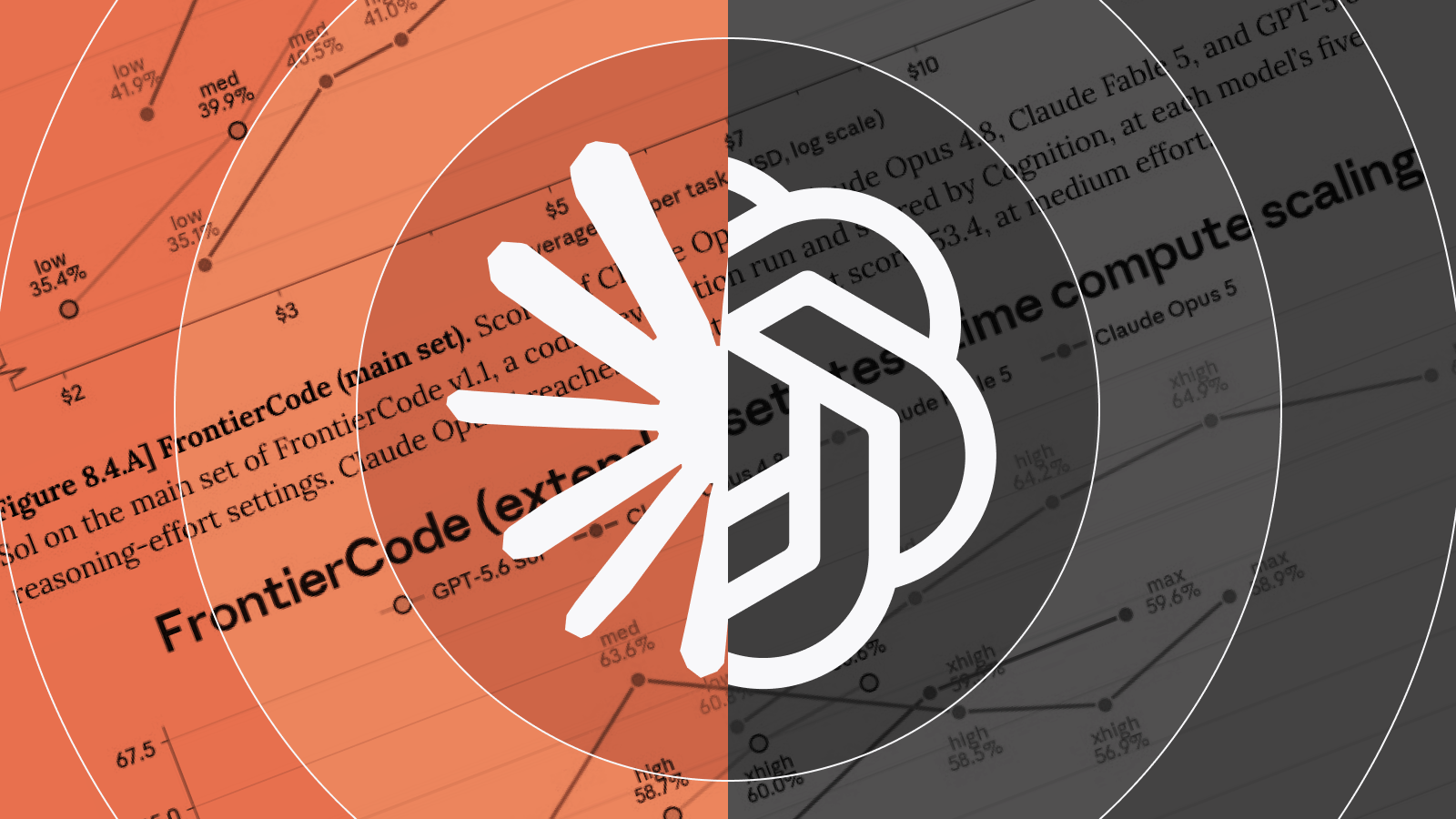
Claude Opus 5 Introduced Near Frontier Intelligence at Half Price
Anthropic's official account announces the new model with benchmark comparisons.

3
India Orders GitHub to Remove Bitchat Repositories
Government cites risks from offline anonymous messaging app using Bluetooth mesh.

4
Unitree Robotics Releases AS2-W Quadruped Robot Video
Shows advanced navigation on cliffs and rough terrain using reinforcement learning.

5
Midjourney Acquires Co-Star Appoints CEO Design Chief
The move brings the astrology app's CEO to lead cross-functional teams at the AI lab.

6
Researcher Withholds Universal Jailbreak Affecting All Major AI Models
AI safety researcher claims universal jailbreak bypasses safeguards on all major models.
7
OpenCode Hits 13 Million Users and $40M Revenue
Open source AI coding platform sees rapid adoption after competitor restrictions.

8
Leaders Endorse Open-Weight AI Models for Ecosystem Health
Tech leaders highlight benefits of open models for AI development and competition.
9
SpaceX Starts Live Webcast for Starship Flight Test
SpaceX prepares thirteenth integrated flight test of its Starship vehicle.
10
Frontier AI Models Score Nearly Identically on Coding Benchmark
Experts discuss non-monotonic performance curves and benchmark quirks for top models.
11
Creative AI Applications Outweigh Prompt Tricks for Claude
Builders discuss why novel applications matter more than optimization tricks when using Claude and similar AI models.
12
AI Inference Compute Will Accelerate Every Scientific Field
Researcher warns academics unprepared as AI inference compute reshapes progress across fields.
13
OpenAI Adds Shareable Links For Custom Pets In ChatGPT
Users generate shareable links for custom AI pets that friends can adopt in ChatGPT.
14
Critics Flag Errors in Claude Opus 5 Chart
AI researchers highlight errors and misleading scales in Claude's performance table.
15
Runway Agent Adds Natural Language Workflows
The feature allows users to build, edit, and run complex node-based workflows using simple natural language prompts.
16
Elon Musk Agrees AI Labs Could Solve Conjectures With Agent Swarms
David Holz speculated major AI labs might assign thousands of AI agents to tackle open conjectures over a weekend.
17
Bend2 Type Checker Switches to BunJS
Victor Taelin reports major performance gains after testing BunJS with Bend2.

18
Handshake Pivots to AI Data Platform
Handshake founder Garrett Lord launched AI data division recruiting STEM talent for model training.
19
Midjourney Releases V8.2 As Default Model
The update emphasizes better aesthetics, personalization, and overall image quality.
20
Ross Taylor Launches BackSearch for Historical Web Searches
Tool provides historical web data via as_of date to avoid future leakage in backtesting.